ACTXDEA4 Ecological Assessment - Eastern Cross Timbers Remnant
A work-in-progress ecological assessment of a 16.78 hectare (41.48 acre) Eastern Cross Timbers mosaic residing just under 8km west of the western Blackland Prairie boundary in the area, and adjacent to I-35E.
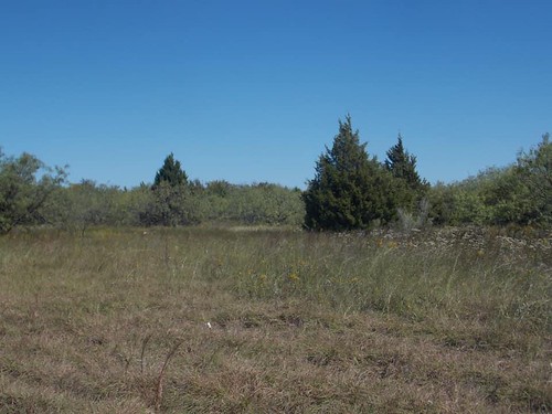
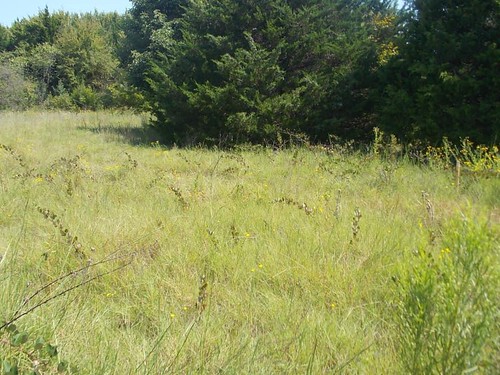
The site is largely open Prosopis-Schizachyrium-Bothriochloa-Iva savanna with areas of dense undergrowth at the ecotonal areas occurring near the south and southeast of the site as it transitions to denser woodlands of Juniperus virginiana, Diospyros virginiana, and Ulmus crassifolia.
A few small depressions at the extreme SE of the site along the drainage of the stream that cuts through the southern half are home to diverse communities of Carex tetrastachya, Typha domingensis, Juncus marginatus, and Limnosciadium pinnatum.
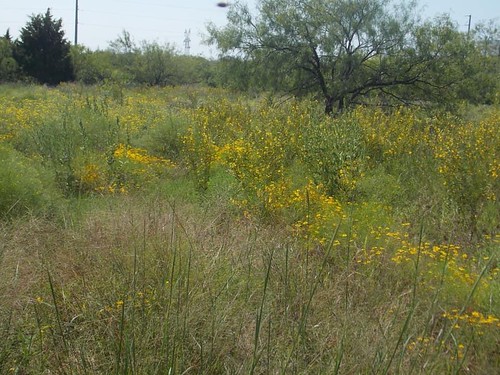
Drier and open upland savanna areas on the eastern half of the site are home to a newly discovered, healthy population of the G2-Imperiled Ipomoea shumardiana as well as the rare (but secure) Chenopodium pallescens.
Soils at the site are ferruginous clay loams with some areas of sandy loam all derived from The Woodbine Formation, and make for a flat topography with relief of around just 10m.
Here’s the species list for the site after just 5 months of assessment every few weeks:
- Acaciella angustissima
- Achillea millefolium
- Acmispon americanus var. americanus
- Agalinis heterophylla
- Allium canadense var. canadense
- Ambrosia psilostachya
- Ambrosia trifida var. texana
- Amphiachyris dracunculoides
- Andropogon ternarius
- Anthoxanthum odoratum
- Asclepias viridis
- Avena fatua
- Baccharis neglecta
- Bifora americana
- Bothriochloa ischaemum var. songarica
- Bothriochloa laguroides subsp. torreyana
- Bradburia pilosa
- Briza minor
- Bromus japonicus
- Carex tetrastachya
- Castilleja indivisa
- Cenchrus spinifex
- Cercis canadensis var. canadensis
- Chamaecrista fasciculata
- Chenopodium pallescens
- Chloris verticillata
- Cirsium altissimum
- Cirsium texanum
- Coleataenia anceps subsp. rhizomata
- Coreopsis tinctoria
- Crocanthemum rosmarinifolium
- Croton capitatus
- Croton lindheimeri
- Croton lindheimerianus
- Croton monanthogynus
- Cyperus acuminatus
- Cyperus bidens
- Cyperus echinacea
- Cyperus entrerianus
- Cyperus esculentus
- Cyperus lupulinus subsp. lupulinus
- Cyperus surinamensis
- Daucus carota
- Daucus pusillus
- Dichanthelium oligosanthes var. scribnerianum
- Diospyros virginiana
- Echinochloa crus-galli
- Eleocharis montevidensis
- Eragrostis cilianensis
- Eragrostis curtipedicellata
- Eragrostis spectabilis
- Erigeron strigosus
- Eriochloa contracta
- Eupatorium serotinum
- Euphorbia bicolor
- Euphorbia davidii
- Euphorbia maculata
- Euphorbia prostrata
- Euphorbia serpens
- Fissidens bryoides
- Fraxinus albicans
- Fraxinus pennsylvanica
- Gaillardia aestivalis var. aestivalis
- Gaillardia pulchella
- Geranium dissectum
- Glandularia bipinnatifida
- Gleditsia triacanthos
- Grindelia ciliata
- Gutierrezia texana
- Helenium amarum var. amarum
- Helianthus annuus
- Heterotheca latifolia
- Hexasepalum teres
- Hordeum pusillum
- Hypericum drummondii
- Hypericum perforatum
- Ilex vomitoria
- Ipomoea cordatotriloba
- Ipomoea shumardiana (CR)
- Iva angustifolia
- Iva annua
- Juncus effusus
- Juncus marginatus
- Juncus tenuis
- Juncus torreyi
- Juniperus virginiana
- Lactuca ludoviciana
- Lactuca serriola
- Lathyrus hirsutus
- Lespedeza cuneata
- Liatris punctata var. mucronata
- Limnosciadium pinnatum
- Linum sulcatum
- Lolium multiflorum
- Lonicera sempervirens
- Lythrum alatum subsp. lanceolatum
- Mimosa quadrivalvis var. platycarpa
- Mollugo verticillata
- Monarda citriodora var. citriodora
- Monarda punctata var. intermedia
- Nekemias arborea
- Nephroia carolina
- Neptunia lutea
- Oenothera speciosa
- Opuntia macrorhiza
- Oxalis dillenii
- Panicum coloratum
- Paspalum dilatatum
- Paspalum floridanum
- Paspalum notatum
- Paspalum pubiflorum var. pubiflorum
- Passiflora incarnata
- Pediomelum tenuiflorum
- Phalaris caroliniana
- Physalis mollis var. mollis
- Pistacia chinensis
- Plantago aristata
- Polypogon monspeliensis
- Polypremum procumbens
- Polytaenia texana
- Prosopis glandulosa
- Prunella vulgaris
- Prunus angustifolia
- Prunus mexicana
- Ptilimnium capillaceum
- Pyrrhopappus pauciflorus
- Quercus fusiformis
- Quercus shumardii
- Rhus glabra
- Rotala ramosior
- Rubus oklahomus
- Rubus pascuus
- Rubus trivialis
- Rudbeckia hirta var. pulcherrima
- Rumex crispus
- Rumex hastatulus
- Sabatia campestris
- Salix nigra
- Schizachyrium scoparium
- Scleria triglomerata
- Setaria parviflora
- Sideroxylon lanuginosum
- Sisyrinchium minus
- Sixalix atropurpurea
- Smilax bona-nox
- Solanum dimidiatum
- Solanum elaeagnifolium
- Solanum rostratum
- Solidago altissima
- Sorghum halepense
- Sphenopholis obtusata
- Symphyotrichum divaricatum
- Symphyotrichum ericoides
- Torilis arvensis
- Toxicodendron radicans subsp. negundo
- Triadica sebifera
- Tridens albescens
- Trifolium campestre
- Triodanis biflora
- Typha domingensis
- Ulmus alata
- Ulmus americana
- Ulmus crassifolia
- Valerianella radiata
- Verbena halei
- Vitis mustangensis
- Weissia controversa
- Zanthoxylum clava-herculis
- Zeltnera texensis
See the images below for more detailed info on substrate and topography of the site:
 ">
">
My observation data-points for plants at the site pulled from iNat, 655 points of 162 species over a 5 month period. From my first visit of the site on May 11th, 2020 to October 12, 2020, my most recent. Some species not uploaded to iNat but present at the site are in the species list.
 ">
">
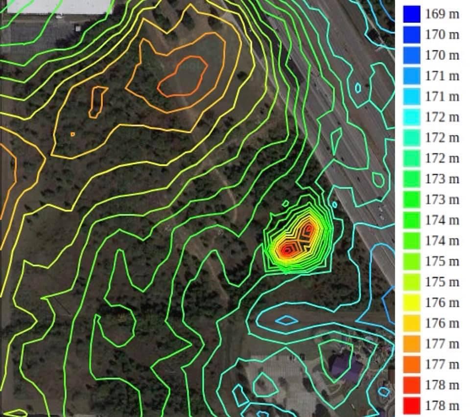
Overview of the site topography, 1m intervals at 20 levels.
 ">
">
Overview of the site topography, 1m intervals at 50 levels.
 ">
">
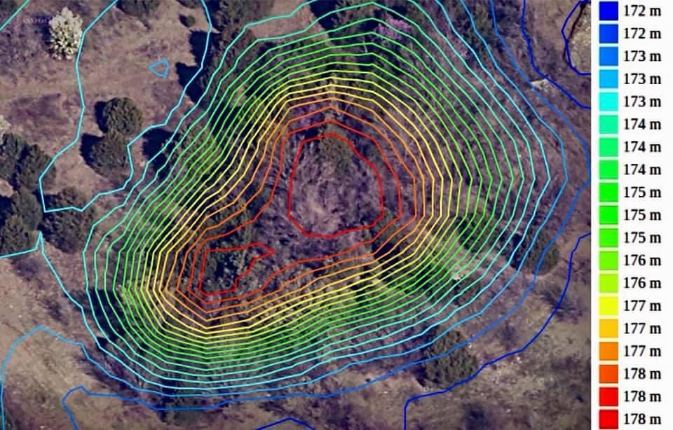
The highest area of the site, a low hill, 1m intervals at 20 levels.
 ">
">
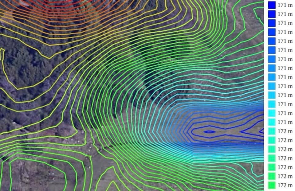
A small depression, 1m intervals at 20 levels.
 ">
">
Soil sections per USGS.
 ">
">
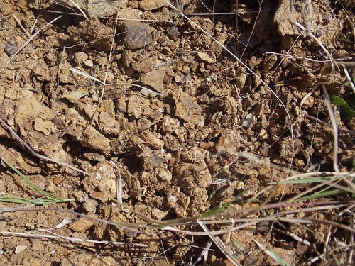
46- Images of the surface layer within section 46 of the soil map after removing a clump of Panicum coloratum. Justin fine sandy loam, 1-3 percent slopes. Well-drained, medium runoff with a moderately slow permeability and easy root penetration. Slightly acid surface to mildly alkaline around 33-80 inches down. This section stretches across the site from Prosopis savanna into open clearing with a diversity of grasses (Schizachyrium scoparium dominating) and to the east into Diospyros woodland.
 ">
">
Open grassland within section 46.
 ">
">
60- The landscape within section 60, Navo clay loam, 1-3 percent slopes. A slightly acid surface becoming moderately alkaline around 72-80 inches deep. Well draining with slow permeability, deep root zone, and medium runoff. This section stretches across the site from west to east but is part of open grassland and savanna throughout, with Schizachyrium scoparium, Juniperus virginiana, Iva angustifolia, and Prosopis glandulosa dominating.
 ">
">
Iva angustifolia covering the surface of the soil in September within section 60.
 ">
">
84- The landscape within section 84, Wilson clay loam, 1-3 percent slopes. Slightly acid surface layer to moderately alkaline around 43-52 inches deep. Poorly drained, with slow runoff and permeability. One of the more diverse areas of the site, with runoff coming from low slopes to the north and south, allowing for a high amount of available moisture. This soil section at the site follows a stream for most of its length before the stream halts to small depressions in the lower pocket of 46. After the stream, the rest of the area within 84 is open grassland with Rubus pascuus canes arching over much of the area, as well as plenty of Gaillardia aestivalis, Passiflora incarnata, and Heterotheca latifolia.
 ">
">
Savanna within section 84.
 ">
">
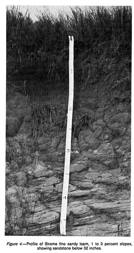
11- Image from Google Earth of the landscape within section 11 on the soil map, Birome fine sandy loam, 1-3 percent slopes. Well-drained, rapid-runoff soil with a relatively limited root zone. Neutral at the surface becoming strongly acidic around 60 inches deep. The foreground is mowed somewhat haphazardly, but the tree line in the background of mostly Juniperus virginiana is home to Chenopodium pallescens.
 ">
">
Section 11 profile from the USDA Denton Co. soil survey.


Comentarios
This is incredibly thorough and valuable work.
Thanks so much @clifton_albrecht! I’ve been very happy to know that so many people see the value in this kind of work.
@sambiology
Aidan, this is really good. Do you know who owns this land? I found it on google maps (https://www.google.com/maps/place/33%C2%B004'32.0%22N+97%C2%B001'28.2%22W/@33.0751678,-97.0270022,1835m/data=!3m1!1e3!4m6!3m5!1s0x0:0x0!7e2!8m2!3d33.0755458!4d-97.0244942), and on a street view on Mcgee Lane, I see it's available for commercial purchase... I'd be very curious if there's any interest from the city of Denton in this sort of purchase, especially if it's known about the ecological significance of this piece of land (using your species list and assessment as evidence).
A few of those picture links are broken for me... Nonetheless, this is really good! Well done, Aidan. :)
Tagging a few others to take a look at this journal entry too: @baxter-slye @gwaithir @aguilita @naturemom @jblinde
Really nice work Aidan! I bet Brand and Diane will be interested to pass this on to their contacts with the City.
Did I miss this part...what made you conduct this survey?
Also, I think this is Lewisville, right?
This is in Lewisville. I drive by it all the time. I often have this thought: "I wonder if there are any good dragonflies or snakes in there?". You can see the now defunct Zone Action Park on FM 407 in the lower right hand corner of the photo.
No idea what’s going on with the pictures, I have them uploaded to Flickr and all set to public, I’ll see if I can go through them soon and fix the links.
I’m not sure who owns the land, there’s some dumping there from the adjacent companies (don’t know them either) but it would be great if there was interest gained from the City of Lewisville. The site is also home to at least a few coyotes and many cottontails.
As for snakes and dragonflies, I haven’t personally seen any snakes though I’d imagine there are plenty. In the spring there are small ephemeral wetlands from the drainage ditches that run through the site to the SE behind the Zone Action Park, McDonald’s & QuikTrip. I’ve seen a good amount of dragonflies there but I haven’t been there yet in early spring when the flora is surely at climax diversity and the grassy wetlands are buzzing.
I have a project set up for my personal surveying of the flora at this site, which you can see the collection of images I’ve taken there of the different plants: https://www.inaturalist.org/projects/ac-plot-4a-personal-survey-2020
Lastly, a link to the write-up I did on what made me conduct this work: https://www.inaturalist.org/journal/aidancampos/45395-goals-and-purpose-of-extensive-ecological-assessments
I plan on doing many more like this in the future, and expanding upon this one once spring comes around!
Also, adding a link to the Facebook post where I originally compiled this info since not all the images are working here: https://www.facebook.com/100022668134891/posts/811865409579056/?d=n
Info from Denton CAD shows ownership of the 42 acres comprised of these 7 parcels split between 6 companies, so the entire area is privately owned. Largest stakeholder (32/42 acres) is owned by a company called Lewisville 33 Partners. Oddly, the only properties this company owns in Denton County are the 3 parcels represented by their 32 acres of this project area, all 3 of which they have held since 2005. These 7 parcels are all zoned light industrial by the city of Lewisville, same zoning as the other parcels off I35 x Justin rd.
https://www.dentoncad.com/home/details?search=98720
https://maps.cityoflewisville.com/
Its really good that you got a solid database of species before this area gets developed. I hope folks can use this info for future restoration/reconstruction projects when we finally decide bulldozing everything isn't sustainable.
Ok my comment sounds a little dismal. With the data you've collected, you have a strong argument for why the City of Lewisville should take an interest in acquiring this land. There are adjacency/infill factors that work in your favor like the trail the runs across Mcgee, and the property owners would have to work around the utility easement crossing these parcels as well. There may be an appetite to put portions of this land under a conservation easement dedicated to the city of Lewisville.
I am interested in doing similar assessments around the streams in Denton, as we have in our development code conditions (depending on stream size) that allow for 50-500ft of easement along our waterways as well as protections for our ESA's. There is a lot of opportunity for connected wildlife corridors along these easements, so I hope to catalog the existing biodiversity of these sites and start building an image of what's there and what's missing. @baxter-slye Future ecology lab project? hahah @aidancampos Your goals and purpose article is really helpful.
It could be a future project!! Or your Master's degree thesis, Brand.
Looks like this property is getting bulldozed and developed for more housing, aka another giant concrete eye-sore on the land. https://communityimpact.com/dallas-fort-worth/lewisville-flower-mound-highland-village/government/2021/04/19/lewisville-oks-rezoning-for-northern-gateway-development/
Shoot.
Wish I had some words of solace, but alas, I don't. :-/ Do know that all of those iNat observations act as historic memories of what 'was' there. @scottking has an amazing blog entry about this sort of loss: https://ofbooksandbugs.wordpress.com/2015/06/13/burning-books/
Any chance of doing some plant rescues before development starts? I've done a few where I just collect EVERYTHING -- even quite a bit of top soil.
Sorry for your loss, Aidan.
With so many sites like these this outcome is inevitable, but I’ll definitely be doing plenty of seed collection and rescues for the rare species there, namely I. shumardiana. If I collect tubers I’m fairly certain I can get them going and reach out to LLELA to find some suitable locations on the property to transplant when ready. Most of the other species there I know to exist in protected areas like LLELA or other nearby parks which is a huge plus. The I. shumardiana of course exists outside of there but is the only population in the county and probably the healthiest of the species in the world.
Let me know how I can help. I can set you up with the volunteers and Richard at LLELA. I also have greenhouse space at UNT. Do you have Richard's contact info?
Aidan, we could even have UNT SER students come help with plant collection. Most are not really answering calls for volunteers right now, but some may be able to help.
Do you know the timeline so we know how long we have? Also, any mammals (like black-tailed jack rabbits) by chance that need a rescue? Or do they have outlets to escape to?
Yikes. Unanimous approval on the zoning change too + complaints about not enough parking.. double yikes. It sucks to see a place you've fallen in love with go like this. I've worked on development stuff like this for a bit and can help out where you want to take this- access permissions, liability waivers, rescue protocols, volunteer organizing...
Agregar un comentario