ACTXDEA4 Ecological Assessment - Eastern Cross Timbers Remnant
A work-in-progress ecological assessment of a 16.78 hectare (41.48 acre) Eastern Cross Timbers mosaic residing just under 8km west of the western Blackland Prairie boundary in the area, and adjacent to I-35E.
The site is largely open Prosopis-Schizachyrium-Bothriochloa-Iva savanna with areas of dense undergrowth at the ecotonal areas occurring near the south and southeast of the site as it transitions to denser woodlands of Juniperus virginiana, Diospyros virginiana, and Ulmus crassifolia.
A few small depressions at the extreme SE of the site along the drainage of the stream that cuts through the southern half are home to diverse communities of Carex tetrastachya, Typha domingensis, Juncus marginatus, and Limnosciadium pinnatum.
Drier and open upland savanna areas on the eastern half of the site are home to a newly discovered, healthy population of the G2-Imperiled Ipomoea shumardiana as well as the rare (but secure) Chenopodium pallescens.
Soils at the site are ferruginous clay loams with some areas of sandy loam all derived from The Woodbine Formation, and make for a flat topography with relief of around just 10m.
Here’s the species list for the site after just 5 months of assessment every few weeks:
- Acaciella angustissima
- Achillea millefolium
- Acmispon americanus var. americanus
- Agalinis heterophylla
- Allium canadense var. canadense
- Ambrosia psilostachya
- Ambrosia trifida var. texana
- Amphiachyris dracunculoides
- Andropogon ternarius
- Anthoxanthum odoratum
- Asclepias viridis
- Avena fatua
- Baccharis neglecta
- Bifora americana
- Bothriochloa ischaemum var. songarica
- Bothriochloa laguroides subsp. torreyana
- Bradburia pilosa
- Briza minor
- Bromus japonicus
- Carex tetrastachya
- Castilleja indivisa
- Cenchrus spinifex
- Cercis canadensis var. canadensis
- Chamaecrista fasciculata
- Chenopodium pallescens
- Chloris verticillata
- Cirsium altissimum
- Cirsium texanum
- Coleataenia anceps subsp. rhizomata
- Coreopsis tinctoria
- Crocanthemum rosmarinifolium
- Croton capitatus
- Croton lindheimeri
- Croton lindheimerianus
- Croton monanthogynus
- Cyperus acuminatus
- Cyperus bidens
- Cyperus echinacea
- Cyperus entrerianus
- Cyperus esculentus
- Cyperus lupulinus subsp. lupulinus
- Cyperus surinamensis
- Daucus carota
- Daucus pusillus
- Dichanthelium oligosanthes var. scribnerianum
- Diospyros virginiana
- Echinochloa crus-galli
- Eleocharis montevidensis
- Eragrostis cilianensis
- Eragrostis curtipedicellata
- Eragrostis spectabilis
- Erigeron strigosus
- Eriochloa contracta
- Eupatorium serotinum
- Euphorbia bicolor
- Euphorbia davidii
- Euphorbia maculata
- Euphorbia prostrata
- Euphorbia serpens
- Fissidens bryoides
- Fraxinus albicans
- Fraxinus pennsylvanica
- Gaillardia aestivalis var. aestivalis
- Gaillardia pulchella
- Geranium dissectum
- Glandularia bipinnatifida
- Gleditsia triacanthos
- Grindelia ciliata
- Gutierrezia texana
- Helenium amarum var. amarum
- Helianthus annuus
- Heterotheca latifolia
- Hexasepalum teres
- Hordeum pusillum
- Hypericum drummondii
- Hypericum perforatum
- Ilex vomitoria
- Ipomoea cordatotriloba
- Ipomoea shumardiana (CR)
- Iva angustifolia
- Iva annua
- Juncus effusus
- Juncus marginatus
- Juncus tenuis
- Juncus torreyi
- Juniperus virginiana
- Lactuca ludoviciana
- Lactuca serriola
- Lathyrus hirsutus
- Lespedeza cuneata
- Liatris punctata var. mucronata
- Limnosciadium pinnatum
- Linum sulcatum
- Lolium multiflorum
- Lonicera sempervirens
- Lythrum alatum subsp. lanceolatum
- Mimosa quadrivalvis var. platycarpa
- Mollugo verticillata
- Monarda citriodora var. citriodora
- Monarda punctata var. intermedia
- Nekemias arborea
- Nephroia carolina
- Neptunia lutea
- Oenothera speciosa
- Opuntia macrorhiza
- Oxalis dillenii
- Panicum coloratum
- Paspalum dilatatum
- Paspalum floridanum
- Paspalum notatum
- Paspalum pubiflorum var. pubiflorum
- Passiflora incarnata
- Pediomelum tenuiflorum
- Phalaris caroliniana
- Physalis mollis var. mollis
- Pistacia chinensis
- Plantago aristata
- Polypogon monspeliensis
- Polypremum procumbens
- Polytaenia texana
- Prosopis glandulosa
- Prunella vulgaris
- Prunus angustifolia
- Prunus mexicana
- Ptilimnium capillaceum
- Pyrrhopappus pauciflorus
- Quercus fusiformis
- Quercus shumardii
- Rhus glabra
- Rotala ramosior
- Rubus oklahomus
- Rubus pascuus
- Rubus trivialis
- Rudbeckia hirta var. pulcherrima
- Rumex crispus
- Rumex hastatulus
- Sabatia campestris
- Salix nigra
- Schizachyrium scoparium
- Scleria triglomerata
- Setaria parviflora
- Sideroxylon lanuginosum
- Sisyrinchium minus
- Sixalix atropurpurea
- Smilax bona-nox
- Solanum dimidiatum
- Solanum elaeagnifolium
- Solanum rostratum
- Solidago altissima
- Sorghum halepense
- Sphenopholis obtusata
- Symphyotrichum divaricatum
- Symphyotrichum ericoides
- Torilis arvensis
- Toxicodendron radicans subsp. negundo
- Triadica sebifera
- Tridens albescens
- Trifolium campestre
- Triodanis biflora
- Typha domingensis
- Ulmus alata
- Ulmus americana
- Ulmus crassifolia
- Valerianella radiata
- Verbena halei
- Vitis mustangensis
- Weissia controversa
- Zanthoxylum clava-herculis
- Zeltnera texensis
See the images below for more detailed info on substrate and topography of the site:
 ">
">
My observation data-points for plants at the site pulled from iNat, 655 points of 162 species over a 5 month period. From my first visit of the site on May 11th, 2020 to October 12, 2020, my most recent. Some species not uploaded to iNat but present at the site are in the species list.
 ">
">
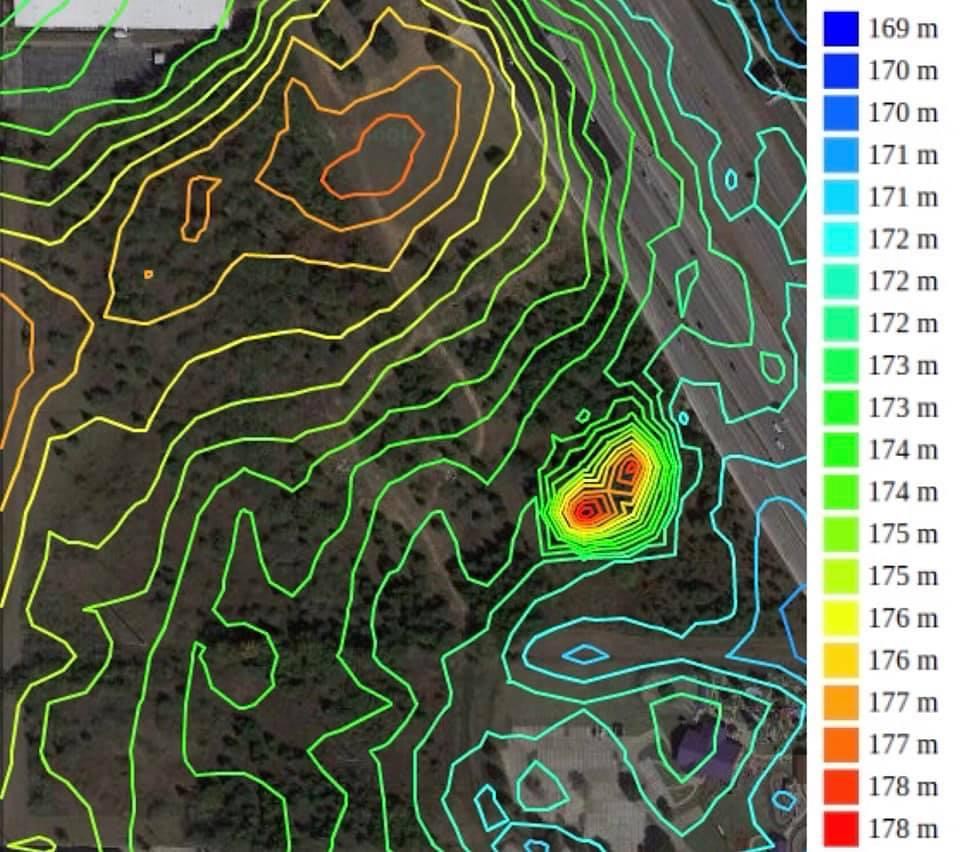
Overview of the site topography, 1m intervals at 20 levels.
 ">
">
Overview of the site topography, 1m intervals at 50 levels.
 ">
">
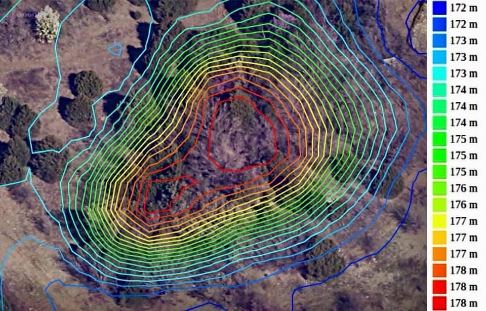
The highest area of the site, a low hill, 1m intervals at 20 levels.
 ">
">
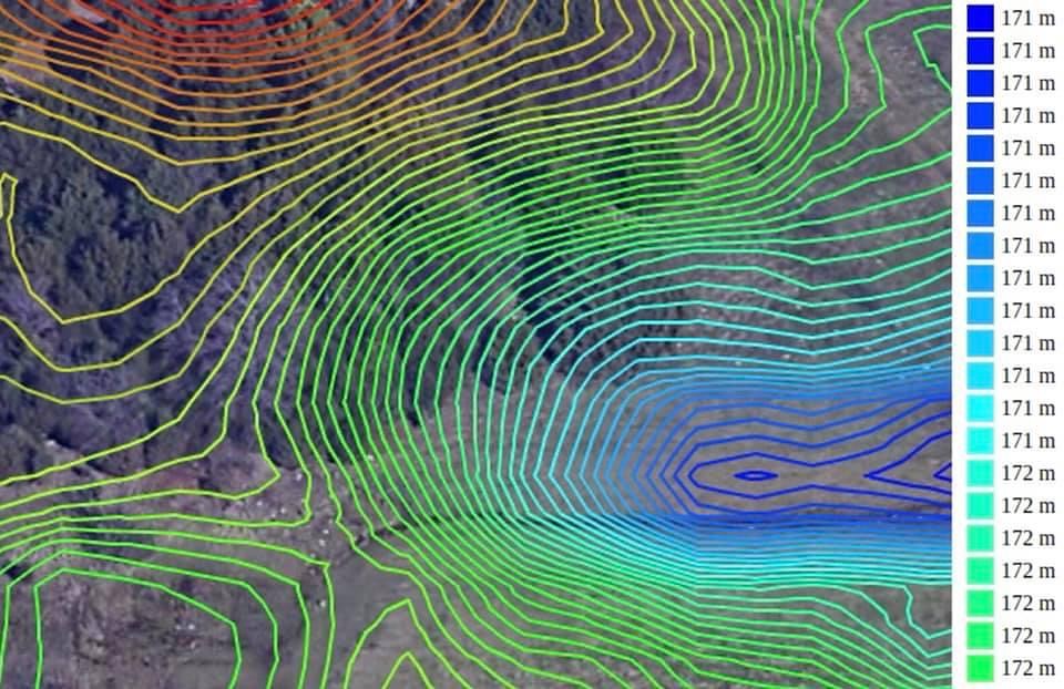
A small depression, 1m intervals at 20 levels.
 ">
">
Soil sections per USGS.
 ">
">
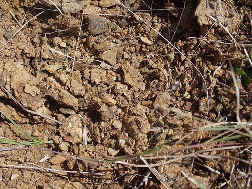
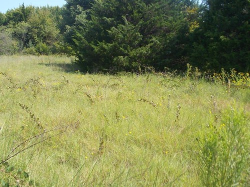
46- Images of the surface layer within section 46 of the soil map after removing a clump of Panicum coloratum. Justin fine sandy loam, 1-3 percent slopes. Well-drained, medium runoff with a moderately slow permeability and easy root penetration. Slightly acid surface to mildly alkaline around 33-80 inches down. This section stretches across the site from Prosopis savanna into open clearing with a diversity of grasses (Schizachyrium scoparium dominating) and to the east into Diospyros woodland.
 ">
">
Open grassland within section 46.
 ">
">
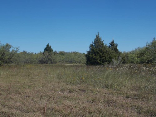
60- The landscape within section 60, Navo clay loam, 1-3 percent slopes. A slightly acid surface becoming moderately alkaline around 72-80 inches deep. Well draining with slow permeability, deep root zone, and medium runoff. This section stretches across the site from west to east but is part of open grassland and savanna throughout, with Schizachyrium scoparium, Juniperus virginiana, Iva angustifolia, and Prosopis glandulosa dominating.
 ">
">
Iva angustifolia covering the surface of the soil in September within section 60.
 ">
">
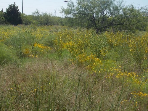
84- The landscape within section 84, Wilson clay loam, 1-3 percent slopes. Slightly acid surface layer to moderately alkaline around 43-52 inches deep. Poorly drained, with slow runoff and permeability. One of the more diverse areas of the site, with runoff coming from low slopes to the north and south, allowing for a high amount of available moisture. This soil section at the site follows a stream for most of its length before the stream halts to small depressions in the lower pocket of 46. After the stream, the rest of the area within 84 is open grassland with Rubus pascuus canes arching over much of the area, as well as plenty of Gaillardia aestivalis, Passiflora incarnata, and Heterotheca latifolia.
 ">
">
Savanna within section 84.
 ">
">
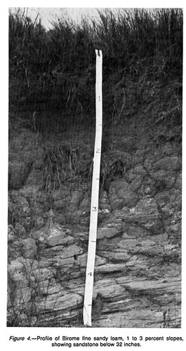
11- Image from Google Earth of the landscape within section 11 on the soil map, Birome fine sandy loam, 1-3 percent slopes. Well-drained, rapid-runoff soil with a relatively limited root zone. Neutral at the surface becoming strongly acidic around 60 inches deep. The foreground is mowed somewhat haphazardly, but the tree line in the background of mostly Juniperus virginiana is home to Chenopodium pallescens.
 ">
">
Section 11 profile from the USDA Denton Co. soil survey.


